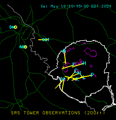
Current Observations
Data values are 15-min averages for period ending 2026-08-02 14:15
** Scroll Table to see rest of data **
| SRS Towers (Measurements at 200 ft above ground) | ||||||
|---|---|---|---|---|---|---|
| Location | Temp. | Humidity | Wind Speed | Wind Dir. | Max Gust | Stability (1) |
| A Area | 85° F | 70 % | 10.1 mph | 158°('SSE) | 16.9 mph | D |
| C Area | 86° F | 66 % | 11.0 mph | 195°('SSW) | 20.2 mph | C |
| D Area | ???° F | ??? % | ??? mph | ???°('???) | ??? mph | ? |
| F Area | ???° F | ??? % | ??? mph | ???°('???) | ??? mph | ? |
| H Area | 86° F | 67 % | 8.4 mph | 171°('S) | 17.8 mph | B |
| K Area | 86° F | 69 % | 9.0 mph | 172°('S) | 18.8 mph | C |
| L Area | ???° F | ??? % | ??? mph | ???°('???) | ??? mph | ? |
| N Area (Climatology) | 85° F | 69 % | 8.4 mph | 183°('S) | 17.4 mph | C |
| P Area | ???° F | ??? % | ??? mph | ???°('???) | ??? mph | ? |
| CSRA Stations | ||||
|---|---|---|---|---|
| Location | Temp. | Humidity | Wind Speed | Wind Dir. |
| Augusta Regional (NWS) | 88° F | 73 % | 9.2 mph | 130°('SE) |
| Daniel Field (NWS) | 86° F | 72 % | 8.1 mph | 150°('SSE) |
| Aiken Airport (NWS) | 87° F | % | 10 mph | 170.0°('S) |
| Barnwell Airport (NWS) | 86° F | 70 % | 3 mph | 230°('SW) |
(1) Pasquill-Gifford stability class (A-F) provides a measure of the atmosphere's ability to disperse
airborne contaminants (Class A = good dispersion, Class F = poor dispersion).
Note: The 200-ft data may at times differ considerably from conditions at ground level,
such as early mornings with clear skies when a strong temperature inversion is present.
SRS & CSRA Plot